The Seminole War

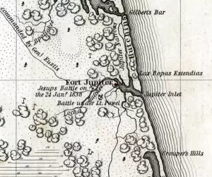
In 1978 when Palm Beach County purchased the land in west Jupiter that is now called Riverbend Park, officials were unaware of its historical importance. Archaeologists hired in the early 1990s uncovered evidence of two 19th century Seminole villages, and of the two Battles of the Loxahatchee, the only battles known to have been fought in Palm Beach County. On January 15, 1838, U.S. Navy Lieutenant Levin M. Powell led 75 army and navy troops against 50 to 60 Seminoles. Nine days later, Major General Thomas Jesup brought 1,500 troops against 100 to 300 Seminoles. Although little known, these battles ended the organized resistance of the Seminoles during the Second Seminole War. After the second battle, Jesup’s troops built Fort Jupiter on a point of land in the Loxahatchee River now called Pennock Point, about three miles west of the Jupiter Inlet. Fort Jupiter closed in 1842, reopened in the 1850s during the Third Seminole War, and closed for good when that war ended.

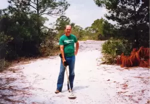
for evidence of Colonel William Lauderdale’s Tennessee Militia camp in Jupiter. Courtesy Richard Procyk
Some of the U.S. soldiers who fought with Jesup were Tennessee Volunteers who did not get along with the regular army soldiers, so instead of staying at Fort Jupiter, the volunteers set up a separate camp about a mile west. In 1989 a group of friends that included Richard Procyk, an avocational archaeologist who had recently moved to Jupiter, located this lost camp of the Tennessee Volunteers in an area that was being developed for housing. Although they got permission for some limited excavation, they were unable to convince the developer to save the campsite; it was lost, except that a granite marker was placed there. At the time, Palm Beach County had no laws to protect historical sites, but the incident prompted the county commission and the Town of Jupiter to pass preservation ordinances.
Hungryland Slough
Shown on early maps as the “West Prong of the Loxahatchee Marsh,” the Hungryland Slough is now part of the J. W. Corbett Wildlife Management Area. Historically its water flowed west to the Everglades (about 19 feet above sea level), but more often it flowed east because the Loxahatchee Slough was lower (about 16 feet above sea level). An Indian midden remains on a hammock island in the southwestern part of the area, which was probably used as a campground for travelers and hunters. The slough was part of a travel corridor between the Everglades and Lake Okeechobee and the Atlantic Ocean, where Indians could pole their dugout canoes to the Loxahatchee River or to the Indian settlements at the Jupiter Inlet.
During the Seminole wars, the Indians sought refuge from the U.S. Army in Hungryland Slough until starvation forced them to surrender. Pioneer ranchers named the area that included the slough “the Hungryland,” for its infertile soil and lack of adequate game or fruits. In the late 1800s Seminoles traveled through Hungryland as earlier natives had done, to visit trading posts at Indiantown and Jupiter.

